


Russian Federation
student
Russian Federation
UDC 332.37
UDC 004.9
UDC 528.2
The development of land management and cadastral documentation is impossible without the use of GIS technologies, which allow obtaining, accumulating and processing information on land resources, creating electronic digital maps with the necessary information in specified combinations. The article discusses the technology of creating a digital model of land and natural resource management in the district. The object of the study is the land and natural resource management systems of the Tevriz municipal district of the Omsk region. Based on the analysis of the existing systems of land and natural resource management, it was established that integrated natural resource management is developing in the region, represented by forestry, agriculture, hunting types of natural resource management and subsoil use. The location of the district in the forest zone determines the specialization of the production sphere in the procurement, production and processing of wood, meat and dairy farming and hunting. The Russian NextGIS platform was used to create the basic layers of the electronic map of the district, the digital model was developed in the MapInfo software product. The technology of obtaining basic layers of the electronic map of the district from the scheme of the Omsk region is presented. The following basic layers are taken as the basis of the future model: administrative border of the district and borders of rural settlements, populated areas, forest resources, surface water bodies and rivers, formed in the form of digital electronic layers with attribute data. The digital model of the existing land and nature management systems of the region includes the following information layers: natural resources, land use system, nature management system, zoning of the territory based on the assessment of natural resource potential. The created digital model is intended, first of all, for the authorities of the municipality to solve the problems of management and development of land and natural resource management systems in the region.
GIS technology, electronic map, land and nature management, information layer, digital model
Введение. Решение задач в сфере использования земельных и природных ресурсов сегодня невозможно без использования геоинформационных систем. Геоинформационные системы (ГИС) – это система сбора, хранения, анализа и графической визуализации пространственных данных (геоданных) (Эзекве, Самойлова, Васильчикова, 2024). Способность хранить и обрабатывать пространственные данные отличает ГИС от других информационных систем.
Информация об объектах землепользования и природопользования (земле- и природопользования) в ГИС представляется отдельными тематическими слоями. Она состоит из графической части в виде электронных карт и атрибутивных данных. Используя массивы данных в ГИС, сочетая разные информационные слои, можно получать тематические электронные карты, выполнять цифровое моделирование (Куракпаев, Машанов, 2016; Цытрон, Ласточкина, Северцов, Казакевич, 2019). Цифровая модель представляет собой модель объекта, в которой в виде совокупности информационных слоев представлены характеристики объекта, обеспечивается их визуализация (Гилёва, Подрядчикова, 2023; Гилёва, Пономарёв, 2024).
Создание цифровых моделей муниципальных образований, как совокупности информации, направлено на сбор, систематизацию, анализ и обновление баз данных. Тематические электронные карты остаются актуальными ввиду отсутствия и устаревания картографического материала. Поэтому управление системой земле- и природопользования на основе цифровых технологий повышает его эффективность (Куракпаев, Машанов, 2016; Гилёва, Пономарёв, 2024; Тесленок, Тесленок, 2016).
Объект исследования. Объектом исследования являются системы земле- и природопользования Тевризского муниципального района Омской области.
Тевризский муниципальный район располагается на севере Омской области. Занимая площадь 981,46 тыс. га, район относится к одному из самых крупных в области (Сайт администрации Тевризского муниципального района Омской области). Распределение земель района по категориям и основным угодьям представлено в таблицах 1 и 2 (Доклад о состоянии и использовании земель в Омской области в 2023 году).
Таблица 1. Распределение земель по категориям
Table 1. Distribution of land by category)
|
Категория земель |
Площадь, га |
|
Земли сельскохозяйственного назначения |
115 531 |
|
Земли населенных пунктов |
2 435 |
|
Земли промышленности и иного специального назначения |
695 |
|
Земли особо охраняемых территорий и объектов |
0 |
|
Земли лесного фонда |
852 803 |
|
Земли водного фонда |
9 996 |
|
Земли запаса |
0 |
|
Итого |
981 460 |
Таблица 2. Распределение земель по угодьям
Table 2. Distribution of land by type of land
|
Наименование угодья |
Площадь |
|
|
га |
% |
|
|
Сельскохозяйственные угодья: |
77 361 |
7,9 |
|
пашня |
35 915 |
3,7 |
|
сенокосы |
29 301 |
3 |
|
пастбища |
11 874 |
1,2 |
|
Несельскохозяйственные угодья: |
904 099 |
92,1 |
|
лесные площади |
619 918 |
63,2 |
|
лесные насаждения, не входящие в лесной фонд |
6 547 |
0,7 |
|
под водой |
23 667 |
2,4 |
|
под дорогами |
6 474 |
0,7 |
|
Болота |
245 219 |
25 |
|
Всего по району |
981 460 |
100 |
На территории района 86,9 % площади занимают земли лесного фонда, закрепляя лесохозяйственный тип природопользования как основной. При этом используются лесные ресурсы (63,9% земель покрыты лесом). Сельскохозяйственный тип природопользования осуществляется на 11,7 % территории района. Площадь сельскохозяйственных угодий составляет 11,7 %, при этом используются почвенные ресурсы и травянистая растительность (Веселова, Рогатнев, Комарова, 2015; Жданов, Веселова, 2018).
Лесохозяйственный тип природопользования осуществляется в границах Тевризского лесничества. Лесохозяйственным регламентом лесничества разрешены 15 видов использования лесов, установлены нормативы их использования (Главное управление лесного хозяйства Омской области. Лесохозяйственный регламент). Фактически предоставляются лесные участки для трех видов использования лесов. Основным видом по количеству заключенных договоров аренды и площади арендуемых лесных участков является заготовка древесины: 24 договора аренды на площади более 100 тыс. га.
Сельскохозяйственное землепользование района представлено тремя хозяйствами: Общество с ограниченной ответственностью (ООО) «Север-Агро», Индивидуальный предприниматель (ИП) Чалимов Н.Ф. и Индивидульный предприниматель (ИП) Бахолдин Я.П. Основная специализация хозяйств – животноводство. Хозяйства используют около 8% площади сельскохозяйственных угодий, 4% площади пашни и 16% площади сенокосов района. Остальные площади сельскохозяйственных угодий используются населением для получения кормов для личного скота.
Для целей охотопользования на территории района располагаются закрепленные охотничьи угодья (ЗОУ) «Тевризское» площадью 34 тыс. га, предоставленные Омской региональной общественной организации "Омское областное общество охотников и рыболовов" (Об утверждении схемы размещения, использования и охраны охотничьих угодий на территории Омской области до 2024 года: Указ от 18 апреля 2014 года № 44).
Также на территории района располагается 63 месторождения полезных ископаемых: газа – 1, нефти – 2, сапропеля – 28, торфа – 32 (Об утверждении Перечня участков недр местного значения на территории Омской области: Приказ от 17 января 2014 года № 2).
Таким образом, на территории Тевризского района осуществляются следующие типы природопользования: лесохозяйственный, сельскохозяйственный, охотохозяйственный и недропользование. Местоположение района в лесной зоне обуславливает специализацию производственной сферы на заготовке, производстве и переработке древесины, мясомолочном животноводстве и охотопользовании (Портал Правительства Омской области. Схема территориального планирования Омской области; Веселова, Бульц, 2024).
Ход и результаты исследования. Целью исследования является разработка пространственной цифровой модели земле- и природопользования Тевризского муниципального района Омской области. Исследование выполнялось в несколько этапов (рис. 1):

Рисунок 1. Этапы выполнения исследования.
Figure 1. Stages of the study.
На I этапе выполнен подбор программного обеспечения для разработки цифровой модели. Разработка цифровой модели земле- и природопользования района выполнялась в ГИС MapInfo Professional с использованием геоданных платформы NextGIS.
ГИС MapInfo Professional предназначена для обработки и анализа пространственной информации. Она достаточно широко используется при выполнении землеустроительных и кадастровых работ. В отличие от других ГИС, у нее достаточно хорошо продуманный интерфейс, оптимизированный набор функций для пользователя, удобная и понятная концепция работы как с картографическими, так и с семантическими данными. Она проста в освоении, обладает большими возможностями для анализа и визуализации данных, интеграции с другими информационными системами и онлайн-сервисами. Она совмещает преимущества обработки данных, которыми обладают базы данных. В программе совмещены эффективные средства анализа и представления данных, а встроенный язык MapBasic позволяет каждому пользователю построить свою ГИС, ориентированную на решение конкретных прикладных задач, снабженную меню, разработанную специально для этого приложения (Блиновская, Задоя, 2023; Веселова, Коцур, Шелёхина, 2019).
Российская платформа NextGIS предназначена для создания и редактирования геоданных, а также работы с ними, позволяет импортировать геоданные, редактировать их и экспортировать обратно. Включает большой набор инструментов для обработки и анализа геоданных и продвинутый графический редактор для оформления карт и подготовки их к печати. Платформа позволяет развернуть географическую информационную систему для организации любого размера, от компании до региона или целой страны (Платформа NextGIS).
На II этапе формировались базовые слои объекта исследования. Основой для них послужили данные с платформы NextGIS на Омскую область. На рисунке 2 представлена последовательность выделения данных Тевризского района из данных Омской области.
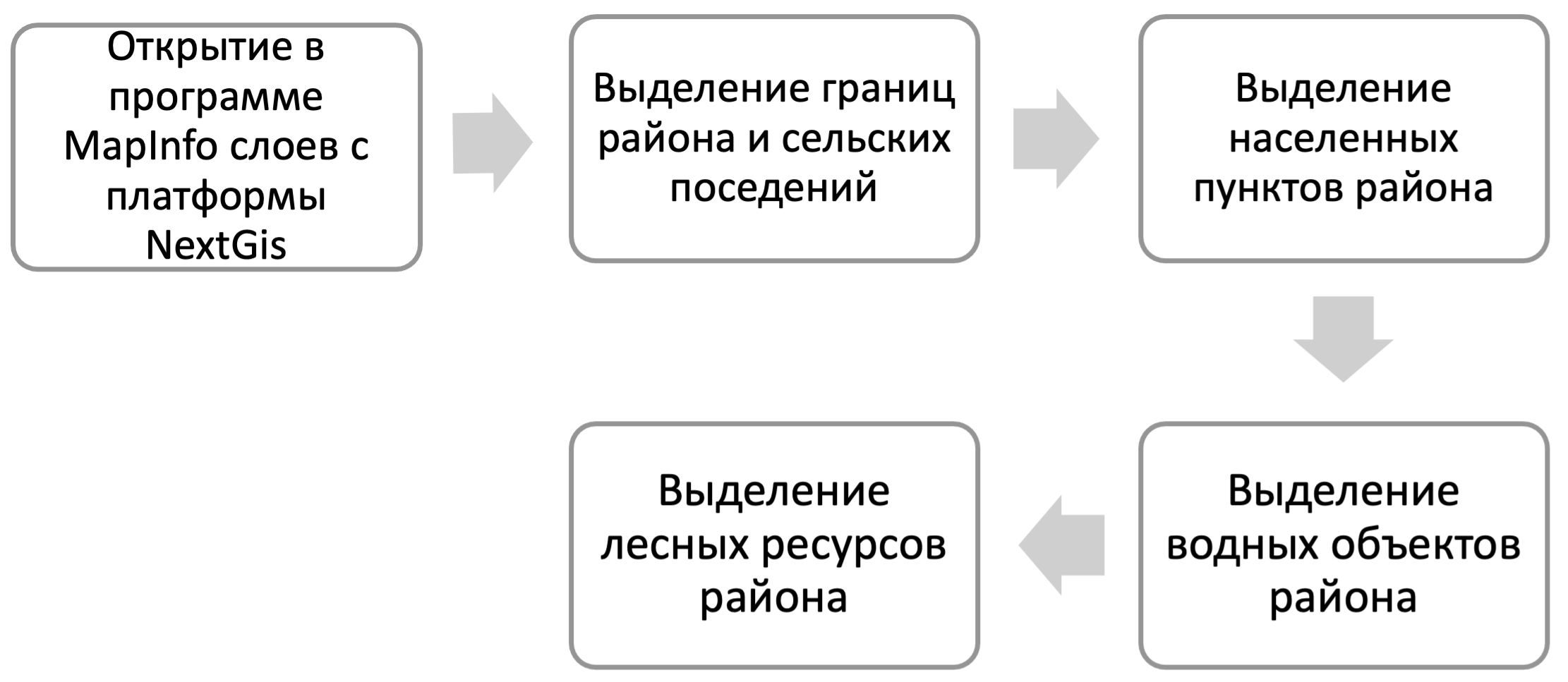
Рисунок 2. Последовательность выделенных данных Тевризского района из данных Омской области.
Figure 2. Sequence of selected data for the Tevriz district from the data for the Omsk region.
Для выделения данных района из данных области использовались стандартные операции работы в программе MapInfo. В качестве примера на рисунке 3 представлена технология выделения слоя реки.

Рисунок 3. Технология выделения слоя реки для Тевризского района.
Figure 3. Technology for identifying the river layer for the Tevriz region.
Последовательное выполнение представленных команд позволяет выделить данные о реках, расположенных в границах Тевризского муниципального района.
Используя вышеприведенную технологию для других данных, получаем базовые слои, которые будут использоваться для создания цифровой модели земле- и природопользования. Для основы будущей модели взяты базовые слои: административная граница района и границы сельских поселений, населённые пункты, лесные ресурсы, поверхностные водные объекты и реки, сформированные в виде цифровых электронных слоев с атрибутивными данными (рис. 4).

Рисунок 4. Цифровые информационные слои для создания цифровой модели.
Figure 4. Digital information layers for creating a digital model.
На III этапе создавалась цифровая модель земле- и природопользования. Цифровая информационная модель представляет собой объектно-ориентированную параметрическую трехмерную модель, в которой в цифровом виде представлены физические, функциональные и прочие характеристики объекта (или его отдельных частей) в виде совокупности информационно насыщенных элементов (Гилёва, Пономарёв, 2024).
Для создания цифровой модели формировались новые информационные слои, включающие совокупность данных о природных ресурсах, землепользовании, природопользовании района. Для характеристики природных ресурсов района в цифровой модели сформированы информационные слои «почвенные ресурсы», «лесные ресурсы», «охотничьи ресурсы», «рыбные ресурсы», «месторождения полезных ископаемых». На рисунке 5 представлен информационный слой почвенные ресурсы. Характеристика системы землепользования включает данные по лесничеству, сельскохозяйственным организациям, закрепленным охотничьим угодьям, месторождениям, а система природопользования – данные по типам природопользования, сложившимся на территории района.
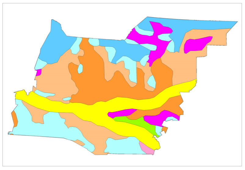
Рисунок 5. Почвенные ресурсы района.
Figure 5. Soil resources of the region.
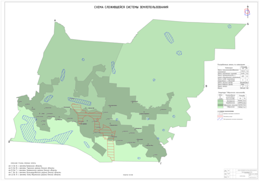
Рисунок 6. Схема сложившейся системы землепользования.
Figure 6. Diagram of the existing land use system.
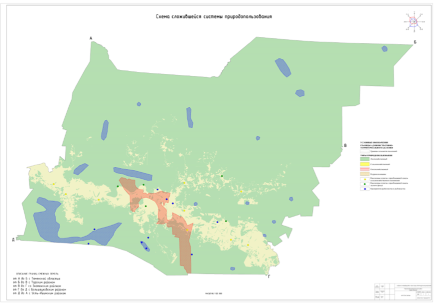
Рисунок 7. Схема сложившейся системы природопользования.
Figure 7. Diagram of the existing system of nature management.
Рисунок 8. Схема зонирования территории по оценке природно-ресурсного потенциала.
Figure 8. Zoning scheme of the territory based on the assessment of natural resource potential.
На основе цифровых информационных слоев объектов земле- и природопользования получены электронные карты сложившихся систем земле- и природопользования района (рис. 6, 7), а также зонирования территории по оценке природно-ресурсного потенциала (рис. 8).
Заключение. Таким образом, цифровая модель земле- и природопользования включает в себя совокупность информационных слоев, которые позволяют создать набор тематических электронных карт:
- Схемы природных ресурсов;
- Схема сложившейся системы землепользования;
- Схема сложившейся системы природопользования;
- Схема зонирования территории по оценке природно-ресурсного потенциала.
Созданная цифровая модель земле- и природопользования является информационной основой управления земле- и природопользованием района. Она содержит данные об объектах земле- и природопользования, позволяет визуализировать пространственную информацию, предоставляет органам управления муниципального образования комплекс тематических электронных карт, позволяющих анализировать современное состояние, принимать обоснованные управленческие решения.
Использование ГИС-технологий позволяет автоматизировать процесс проектировать, визуализировать сложившуюся пространственную информацию, ускоряет процесс создания землеустроительной и кадастровой документации и повышает её качество.
1. Ezekwe K. S., Samoilova A. D., Vasilchikova E.V. Analysis of existing QGIS and NEXTGIS modules for the use of GIS-technologies in land management and cadastry // Property management, land management and geodesy issues.2024;2(6):56-65. (In Russ.) EDN: https://elibrary.ru/IEQQLH
2. Kurakpaev O. T. L., Mashanov A. A. Possibilities of using GIS technologies in land management and land cadastre // Bulletin of the Kyrgyz-Russian Slavic University. 2016;5-16:154-156. (In Russ.) EDN: https://elibrary.ru/WGWOUP
3. Tsytron G. S., Lastochkina S. I., Severtsov V. V., Kazakevich N. A. Experience in using GIS technologies in the creation, updating and preparation of digital large-scale topographic maps for publication for land management and cadastral purposes // Bulletin of the Belarusian State Agricultural Academy. 2019;2:229-233. (In Russ.) EDN: https://elibrary.ru/DDUPVQ
4. Gileva L. N., Podryadchikova E. D. The use of digital technologies in the formation of a map of environmental restrictions // Moscow Economic Journal. 2023;3-8. (In Russ.) DOI: https://doi.org/10.55186/2413046X_2023_8_3_98; EDN: https://elibrary.ru/GOYQUN
5. Gileva L. N., Ponomarev M. V. Formation of a digital model of municipal land use for effective territory management // Sustainable Development of the Land and Property Complex of a Municipality: Land Management, Cadastral, and Geodetic Support. A Collection of Scientific Papers Based on the Proceedings of the 5th National Scientific and Practical Conference. Omsk. 2024. – p. 194–200. (In Russ.) EDN: https://elibrary.ru/KOGKRV
6. Teslenok K. S., Teslenok S. A. Geoinformational technologies in the management of natural resources // Current Issues in Humanities and Social-Economic Sciences. 2016;4-10:107-112. (In Russ.) EDN: https://elibrary.ru/VVZITF
7. Administration of the Tevriz District of the Omsk Region. URL: https://tevrizskij-r52.gosweb.gosuslugi.ru/ (accessed: 03.07.2025)
8. Report on the state and use of land in the Omsk region in 2023. URL: http://mgpr.omskportal.ru/ru/municipal/localAuthList/3-52-2061/officialsite/rosree str/2017/40.html (accessed: 22.08.2024)
9. Veselova M. N., Rogatnev Yu. M., Komarova S. Yu. Territorial Organization of Nature Management: a study guide // Omsk: Omsk State Agrarian University named after P. A. Stolypin. 2015. – 132 p. (In Russ.) EDN: https://elibrary.ru/WBQAEV
10. Zhdanov A. Y., Veselova M. N. Peculiarities of the organization of use of the land of Muromtsevsky forestry of the Omsk region // Youth Science 2018: Research, Technology, and Innovation in Geodesy, Land Management, and Cadastre. Annual collection of scientific papers on mathematics. XXIV Scientific and Technical Student Conference. 2018. – p. 83–87. (In Russ.) EDN: https://elibrary.ru/YMEJOH
11. Main Forestry Directorate of Omsk Region / Forestry Regulations. URL: https://gulh.omskportal.ru/oiv/gulh/otrasl/lesregl/2013-25-01 (accessed: 27.12.2024)
12. On approval of the plan for the placement, use, and protection of hunting grounds in Omsk Oblast until 2024: Decree No. 44 of April 18, 2014. / Electronic fund of legal and regulatory documents. Decree No. 44 of April 18, 2014. URL: https://docs.cntd.ru/document/550161593 (accessed: 12.11.2024)
13. On approval of the List of subsoil areas of local significance in the Omsk region: Order of January 17, 2014 No. 2. / Electronic fund of legal and regulatory documents. URL: https://docs.cntd.ru/document/467311089 (accessed: 12.11.2024)
14. Portal of the Government of the Omsk Region / Territorial planning scheme of the Omsk Region. URL: https://omskportal.ru/shema-ter-planirovania (accessed: 27.12.2024)
15. Veselova M. N., Bultz V. A. Analysis of the existing systems of land and nature management of the Tervis district of the Omsk region // Sustainable Development of the Land and Property Complex of a Municipality: Land Management, Cadastral, and Geodetic Support. A Collection of Scientific Papers Based on the Proceedings of the 5th National Scientific and Practical Conference. Omsk. 2024. – p. 157–162. (In Russ.) EDN: https://elibrary.ru/CBXAJE
16. Blinovskaya Ya. Yu., Zadoya D. S. Introduction to Geographic Information Systems: a study guide // Moscow: FORUM: INFRA-M. 2023. – 112 p. (In Russ.)
17. Veselova M. N., Kotsur E. V., Shelyokhina Ya. E. Using GIS technologies in training specialists in land management and cadastral surveys // Digital agriculture in the region: key objectives, promising areas, and systemic effects. Collection of materials from the international scientific and practical conference dedicated to the 70th anniversary of the Faculty of Economics. Omsk. 2019. – p. 264–268. (In Russ.) EDN: https://elibrary.ru/DPXLLK
18. NextGIS platform. URL: https://nextgis.ru/about/ (accessed: 05.03.2025)